
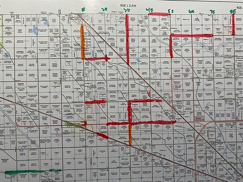
Updated Road Closures
UPDATED Road Closure Map
When:
Public Works
Please see the attached map for the most updated road closures. Please note:
Red Lines: Closed
Orange Lines: Down to one lane
Green Lines: Open
The following is the updated list of road closures within the Rural Municipality of Rosser as of 12:44pm on Friday, June 12, 2026:
- Road 3 East, between PTH 6 and Road 72 North.
- Road 3 East, between Road 67 North and Road 68 North.
- Road 68 North, between Road 4 East to PTH 6.
- Road 68 North, between Road 1 East and 3 East.
- Road 67 North, between Road 2 East and Road 5 East.
- Sturgeon Road (Road 8 East), between Road 71 North and 72 North.
- Road 71 North, between PR 236 to Summit Road (Road 7 East).
- Road 5 East, between Road 70 North and 71 North.
- PR 321 (Road 72 North), between Road 4 East and Road 5 East.
- PR 221, between Road 1 East and Road 2 East.
- Road 70 North, between Road 1 East to Road 2 East.
In addition, the following roads are restricted to single lane traffic:
- Road 3 East, between Road PR 221 and 67 North.
- Road 1 East, between Road 70 North and PTH 6.
- Intersection of 1 East and 67 North (North and West sections).
The following roads have been re-opened:
- Road 65 North, between Meridian and RM of St. Francis boundary.